Synopsis:
Any morning clouds will give way to mostly sunny skies today. It will be cool as high pressure moves in from the West.
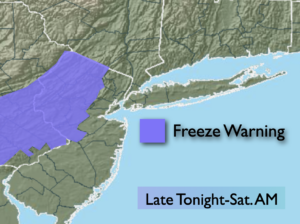
Tonight will be cold under partly cloudy skies. A Freeze Watch has been posted for the area, excluding New York City. Readings will be near or below freezing throughout.
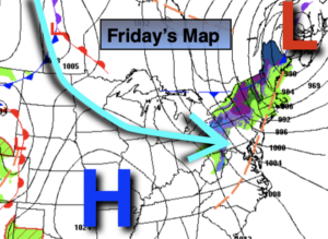
On Friday, sun will give way to clouds. Spotty PM showers are possible with weak low pressure approaching.
Saturday will start off damp with showers but the sun will return during the afternoon. Sunday will be mostly sunny as high pressure settles over the area.
Monday will be partly sunny as a storm moves up and off the coast, not affecting the area.
Stay Tuned.
Keep it here for a no nonsense, no hype forecast.
Today:
Partly sunny, breezy. Highs in the lower 50s. Northwest winds at 10-20mph.
Tonight:
Partly cloudy and cold. Lows in the mid 30s in the City, the 20s to around freezing inland. Northwest winds diminishing to 5-10mph.
Friday:
Partly sunny. Slight chance of PM Showers. Highs in the lower 50s.
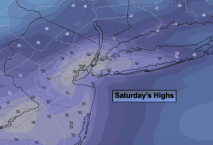
Saturday:
Morning showers, otherwise becoming partly sunny. Highs in the lower to mid 50s.
Sunday:
Mostly sunny, more seasonal. Highs around 60º.
Monday:
Partly sunny. Highs in the lower 60s.
***Please take “social distancing” seriously during this time. We will get through this.****