Synopsis:
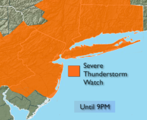
***Severe Thunderstorm Watch for the entire tri-statea area until 9PM***
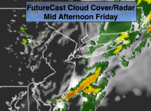
The hot and humid conditions will come to end as a front pushes into the area this evening. We’ll have to pay the price though as scattered severe thunderstorms are possible later this afternoon and evening. Severe Storms contain winds in excess of 58mph and or one inch hail. Torrential rain and frequent lightning will accompany the storms. Keep an eye to the sky for threatening weather conditions.
A Flash Flood Watch is up for many areas for the possibility of heavy rain which could cause flooding. 1-3″ of rain is possible by Friday Night. If you see a flooded roadway, turn around don’t drown.
By Friday, the front will slip to the South, cooling us off considerably but on and off rain and spotty storms will remain in the forecast due to the proximity of the front. Some of the rainfall maybe heavy.
The weekend will be a winner with plenty of sunshine, warm temperatures and low humidity as the front moves offshore and weak high pressure moves in.
Stay tuned.
This Evening & Tonight:
Mostly cloudy with scattered showers and thunderstorms. Some of the storms maybe severe early. Torrential rain is possible is spots. Lows in the 60s. Winds becoming Northeast at 5-10mph.
Friday:
Much cooler with on and off rain and spotty storms. Some of the rain maybe heavy. Highs in the lower 70s. Northeast 5-10mph.
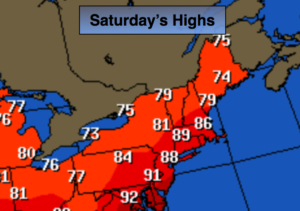
Saturday:
Partly sunny and less humid. Highs in the lower 80s.
Sunday:
Mostly sunny and warm. Highs in the lower 80s.
Monday:
Partly sunny and warm. Spotty PM Storms. Highs in the mid 80s.
Tuesday:
Partly sunny and warm. Spotty PM Storms. Highs in the mid 80s.
Keep it here for a no nonsense, no hype forecast.