Synopsis:
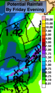
An area of low pressure will develop along a front tonight and move off the coast Friday morning. The atmosphere is moisture laden and the rain could be heavy at times. Where the axis of heavy rain falls is in question. A swath of 1″-2″ of rain is possible by Friday. The possible rainfall amounts are above. If heavy rain persists for a time in one location flash flooding could occur. Remember if you experience a flood roadway- turn around don’t drown.
The sun should return later Friday morning or afternoon. A spotty afternoon or evening storm can’t be ruled out.
The upcoming weekend looks decent with plenty of sunshine and warm readings. A stray afternoon or evening storm is possible on Saturday, most areas will remain rain-free. Sunday will be spectacular with abundant sunshine and lower humidity as high pressure takes hold.
Tonight:
Scattered showers. Areas of steady rain with local downpours. Chance of thunderstorms. Lows in the 60s throughout. Muggy. Southeast to East wind at 5mph.
Friday:
Areas of steady rain with local downpours in the morning. Some Afternoon sun. A stray late day storm is possible. Humid. Highs in the lower 80s. East to North winds at 8-12mph.
Saturday:
Partly sunny. A stray afternoon storm is possible. Highs in the mid 80s.
Sunday:
Sunny. Highs in the lower to mid 80s.
Monday:
Partly sunny. Highs in the mid 80s.
Tuesday:
Partly sunny. A spotty afternoon storm. Highs in the mid 80s.
Keep it here for a no nonsense, no hype forecast.