Synopsis:
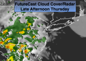
Today into Friday will be unsettled with times of showers and storms as a front moves in with an area of low pressure. It will not be a washout. Today will be mainly cloudy. Showers are possible, mainly West of NYC(FutureCast radar above). It’ll be cooler than recent days. A period of heavier rain is possible tonight.
Showers are possible early Friday but much of the day should feature partly sunny skies. An stray afternoon or evening storm can’t be ruled out.
The upcoming weekend looks like a gem with plenty of sunshine, warm readings and lowering humidity.
Today:
Mainly cloudy. Chance of showers, mainly West of the City. Cooler. Highs in the upper 70s. Southeast winds at 5-10mph.
Tonight:
Periods of rain. Local downpours. Chance of thunderstorms. Lows in the 60s throughout. Northeast wind at 5mph.
Friday:
Any morning showers will give way to a mix of sun and clouds. A stray late day storm is possible. Humid. Highs in the lower 80s.
Saturday:
Mostly sunny. Highs in the mid 80s.
Sunday:
Mostly sunny. Highs in the lower 80s.
Monday:
Partly sunny. Highs in the mid 80s.
Keep it here for a no nonsense, no hype forecast.