Synopsis:
Two systems will continue to influence our weather through tomorrow. High pressure in the Western Atlantic will pump up a very warm and tropical airmass. At the same time a front to our North will bump up against the heat. This will cause spotty showers and storms each afternoon and evening. By Friday, the front will slip to the South, cooling us off considerably but showers remain in the forecast due to the proximity of the front.
The weekend will be a winner with plenty of sunshine, warm temperatures and low humidity.
Stay tuned.
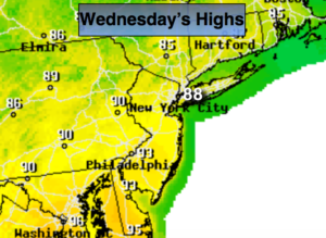
Today:
Partly sunny. Humid. Spotty afternoon and evening storms. Highs in the upper 80s. West to Southwest winds at 8-12mph.
Tonight:
Partly cloudy, muggy and very warm. An isolated shower or storm is possible. Lows in the mid to upper 70s in the City, near 70º inland. West to Southwest wind 5mph.
Thursday:
Hazy, hot and humid. Scattered afternoon showers and storms. Some of the storms may contain strong winds and torrential rain. Highs in the lower 90s. Heat index will be 95º-100º.
Friday:
Much cooler with scattered showers. Highs in the upper 70s.
Saturday:
Mostly sunny and less humid. Highs in the lower 80s.
Sunday:
Mostly sunny and warm. Highs in the lower 80s.
Keep it here for a no nonsense, no hype forecast.