Synopsis:
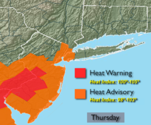
One more hot and humid day is on the way for today. A Heat Advisory has been issue for NYC and parts of NJ for temperatures in the lower 90s and high humidity. The combination of these two conditions will make it feel close to 100º at times. Please drink plenty of fluids and stay out of the sun if possible.
Scattered storms are expected to develop by mid-afternoon and continue into the evening. A few of the storms may become severe. Torrential rain and frequent lightning will accompany the storms.
By Friday, the front will slip to the South, cooling us off considerably but on and off rain and spotty storms will remain in the forecast due to the proximity of the front. Some of the rainfall maybe heavy.
The weekend will be a winner with plenty of sunshine, warm temperatures and low humidity as the front moves offshore and weak high pressure moves in.
Stay tuned.
Today:
Hazy, hot and humid. Scattered afternoon showers and storms. Some of the storms may contain strong winds and torrential rain. Highs in the lower 90s. Heat index will be 98º-103º. West to Southwest winds at 10-20mph.
Tonight:
Mostly cloudy with scattered showers and thunderstorms. Some of the rainfall could be heavy. Lows in the 60s. Winds becoming Northeast at 5-10mph.
Friday:
Much cooler with on and off rain and spotty storms. Some of the rain maybe heavy. Highs in the lower 70s.
Saturday:
Partly sunny and less humid. Highs in the lower 80s.
Sunday:
Mostly sunny and warm. Highs in the lower 80s.
Monday:
Partly sunny and warm. Spotty PM Storms. Highs in the mid 80s.
Keep it here for a no nonsense, no hype forecast.