Synopsis:
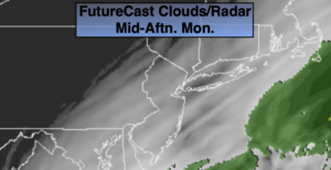
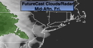
Today will be a changeable day with a rapidly moving front approaching. There will be times of clouds and some sun today. Showers are expected and possibly a thunderstorm (an isolated severe storm is possible) with the passage of the front toward midday through mid afternoon (map above). The sun will return after the front moves through and the wind will increase dramatically. Winds may gust to 45mph by late day. Readings will near the average high of the lower 60s.
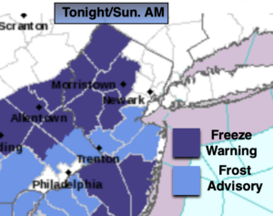
Tonight will be clear, windy and cold. A Freeze Warning is in effect for the area excluding New York City. Wind chills will be in the 20s.
Wednesday will be blustery and chilly under mostly sunny skies as the flow will continue out of Canada.
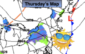
A storm will develop over the Ohio Valley on Thursday. Any sun will give way to clouds and an increasing chance of rain through the afternoon. Friday will be wet as the low passes through the region.
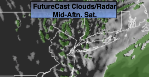
Hopefully, we’ll squeeze out a dry Saturday as we’ll be in between systems.
Stay Tuned.
Keep it here for a no nonsense, no hype forecast.
Today:
Clouds & sun. Scattered showers and possible thunderstorms. Becoming windy during the afternoon. Highs around 60º. Southwest to Northwest winds increasing to 15-30mph with gusts to 45 later in the day.
Tonight:
Mostly clear, windy and cold. Lows in the mid 30s in the City, the 20s to around freezing in the ‘burbs. West to Northwest winds at 15-30mph with gusts to 40mph early.
Wednesday:
Mostly sunny, breezy and chilly. Highs only in the lower 50s.
Thursday:
Morning sun, otherwise increasing clouds with a chance of late day rain. Highs in the mid to upper 50s.
Friday:
Rain likely. Highs in the mid 50s.
Saturday:
Partly sunny. Highs in the upper 50s.