Synopsis:
Happy Hanukkah!
Today will be the calm before the storm. Abundant sunshine is expected as Canadian high pressure influences the region with chilly readings.
Skies will be clear tonight and it will most likely be the coldest night of the season so far.
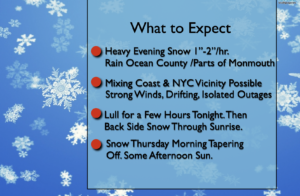
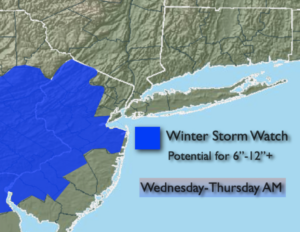
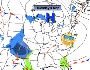
All of the computer models are in agreement that a storm will affect the region for Wednesday afternoon into Thursday morning. There are some differences with the models (but that is expected). The potential continues that a significant snowfall will occur for most of the tri-state area. A mix is also possible at the coast and to the South. The storm will develop along the Delmarva Peninsula Wednesday afternoon and move just offshore of the NJ coast Wednesday Night.
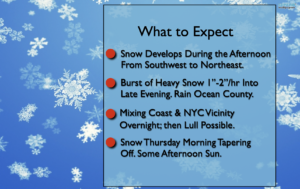
Wednesday will start off with some sunshine but clouds will increase and thicken during the day. A swath of light snow will move into the area from Southwest to Northeast during the afternoon. As the storm gets cranking along the coast the snow will become heavy at times at night. Enough mild air will work in off the ocean for mainly rain for Southern NJ. The heavy snow may mix with sleet and or freezing rain in the immediate NYC vicinity and over Long Island.
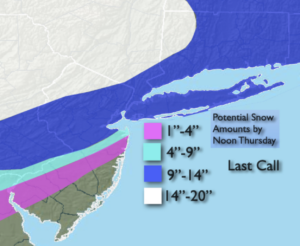
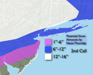
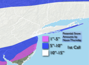
1st call snow amounts have been posted above. Many regions have the potential for around a foot of snow. These bands will change as we get closer to the event. Wind will also be any issue with gusts up to 45mph possible, especially at the coast. Isolated power outages are possible. Coastal flooding may occur at times of high tide Thursday morning.
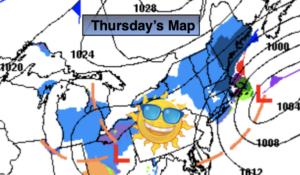
The storm will move offshore Thursday taking the snow with it by late morning through early afternoon. The sun will return.
Friday and Saturday will be more tranquil as Canadian high pressure dominates. Sunny, cold conditions are expected.
Stay Tuned.
Keep it here for a no nonsense, no hype forecast.
Today:
Mostly sunny and cold. Highs in the upper 30s. Northwest winds at 8-12mph.
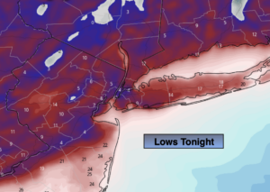
Tonight:
Mostly clear and very cold. Lows in the mid 20s in urban areas, 10º-20º inland. Northwest to East winds at 5mph.
Wednesday:
Thickening clouds. Snow developing later in the afternoon. A mix possible South. Highs 30º-35º.
Thursday:
Morning sunshine to late day snow. Cold. Highs around freezing.
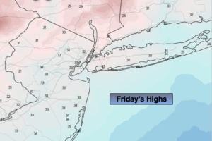
Friday:
Sunny. Cold. Highs in the mid 30s.
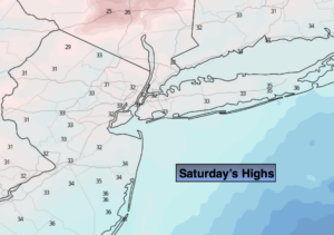
Saturday:
Mostly sunny. Cold. Highs in the mid 30s.