Synopsis:
Happy Hanukkah!
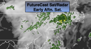
The weekend will be Spring-like as a Southwesterly flow continues around a Western Atlantic high . Today will be a grey day with scattered showers, mainly by the coast as a weak disturbance moves through. The activity will move offshore during the afternoon.
Sunday will be the better half of the weekend with the sun returning as a weakening cool front washes out over the region. Highs will approach 60º.
Monday skies will be mostly cloudy as a wave of low pressure develops on an offshore front. A period of rain is likely for areas South and East of the City with a threat of wet snow or a mix from the City and to the North and West. An accumulation of snow is possible inland.
Tuesday will be the calm in between systems. Abundant sunshine is expected as Canadian high pressure influences the region. It will be cold.
All of the computer models are in general agreement that a storm will affect the region for Wednesday afternoon into Thursday morning. The potential has increased that some areas will receive an accumulating snow. A mix is also possible at the coast and to the South.
Stay Tuned.
Keep it here for a no nonsense, no hype forecast.
Today:
Cloudy. Scattered showers, best chance will be along the coast. The showers will move offshore during the afternoon. Mild. Highs in the mid to upper 50s. East to Southeast winds at 5-10mph.
Tonight:
Mostly cloudy. Mild. Lows around 50º in urban areas (that’s five degrees above the average high of 45º), around 40º inland. Southwest winds less than 5mph.
Sunday:
Sun and clouds. Warm. Highs in the 50s to around 60º.
Monday:
A period of rain or a mix along the coast. A period of snow inland. Some accumulation possible North and West. Highs in the lower 40s.
Tuesday:
Mostly sunny and cold. Highs in the upper 30s.
Wednesday:
Thickening clouds. Potential for afternoon snow. Highs 30º-35º.