Synopsis:
Happy Hanukkah!
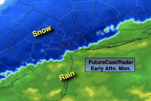
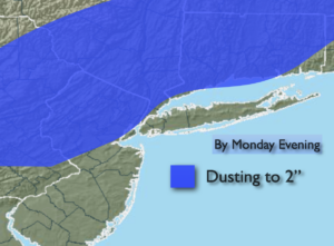
A wave of low pressure will develop on an offshore front today. A period of rain is likely for areas South and East of the City with wet snow North and West of the City. Even in the City and some coastal areas the rain will go over to wet snow during the afternoon. A light accumulation is possible North and West by late day. Isolated amounts of 3″ are possible over the highest elevations.
Tuesday will be the calm in between systems. Abundant sunshine is expected as Canadian high pressure influences the region. It will be cold.
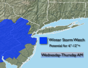
All of the computer models are in general agreement that a storm will affect the region for Wednesday afternoon into Thursday morning. It is quite rare for all of the models this far out to basically have the same output. For this reason the potential continues to increase that a significant snowfall will occur for most of the tri-state area. A mix is also possible at the coast and to the South. It is way too early to call for amounts, just know that if the track remains the same with the models today that a plowable snow and then some will occur. Early call thinking is 6″ to 12″. A Winter Storm Watch is in effect for Wednesday into Thursday morning for parts of NJ. These Watches will be expanded to include areas to the North and East within the next 24 hours.
Thursday morning snow will end and the sun will return.
A tranquil close the the week is expect behind the storm on Friday.
Stay Tuned.
Keep it here for a no nonsense, no hype forecast.
Today:
A period of rain or a mix along the coast. A period of snow inland. Some accumulation possible North and West. Early highs in the near 40º along the coast falling into the 30s. Inland readings will fall close to freezing. North wind at 5-10mph.
Tonight:
Clearing skies, much colder. Lows around 30º in urban areas, the 20s inland. Northwest increasing to 10-20mph.
Tuesday:
Mostly sunny and cold. Highs in the upper 30s.
Wednesday:
Thickening clouds. Snow developing. A mix possible South for a time. Highs 30º-35º.
Thursday:
Morning snow to sunhine. Cold. Highs around freezing.
Friday:
Sun and clouds. Cold. Highs in the mid 30s.