Synopsis:
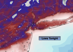
Tonight will be frigid, especially inland with deep snowpack and calm conditions. Readings will dip into the single digits and teens in the ‘burbs. High pressure will be in control assisting in the major drop in temperatures.
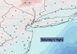
A bright, cold Saturday is expected with little if any wind.
Temperatures will moderate Sunday and Monday under a mix of sun and clouds as weak fronts push through with little fan fare. There could be a few flurries or showers later Sunday evening into Monday morning. Winter arrives Monday at 5:02AM.
Tranquil conditions will be with us through midweek with readings near seasonal levels. The average high temperature is around 40º.
Stay Tuned.
Keep it here for a no nonsense, no hype forecast.
Tonight:
Partly cloudy and very cold. Lows in the lower 20s in the City, the single digits and teens inland. North wind at 5mph.
Saturday:
Partly sunny. Cold. Highs in the mid 30s. North to Southwest winds at 5mph.
Sunday:
More clouds. Not as harsh. Chance of late day showers or flurries. Highs around 40º.
Monday:
Possible early showers or flurries, otherwise becoming partly sunny. Highs in the lower 40s.
Tuesday:
Party sunny. Highs in the lower 40s.