Synopsis:
Today will feature high pressure building into the region. Plenty of sunshine and warm readings are anticipated. It’ll be a top ten day with low humidity!
The weekend won’t be stellar, but it won’t be a washout. Saturday will feature sun and clouds. The clouds will win the battle during the afternoon and spotty showers can’t be ruled out as a disturbance moves in from the West.
On Sunday clouds will dominate as moisture from the South and the disturbance from the West combine resulting in a better chance of showers. Readings will be near seasonal averages for the date.
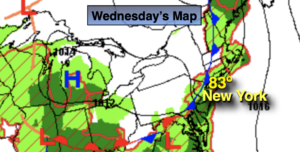
It’ll be a nice start to the week with sunny, warm readings through Tuesdsay as high pressure moves in from the West.
Stay tuned.
Keep it here for a no hype, no nonsense forecast.
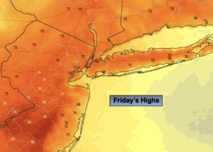
Friday:
Mostly sunny. Highs around 80º. West winds at 5-10mph.
Tonight:
Becoming mostly cloudy late. Lows in the mid 60s in the City, the 50s inland. West to Northeast winds at 5mph or less.
Saturday:
Clouds and sun. Spotty afternoon showers possible. Highs in the mid to upper 70s.
Sunday:
Mostly cloudy with scattered showers. Highs in the mid 70s.
Monday:
Partly sunny. Warm. Highs in the lower 80s.
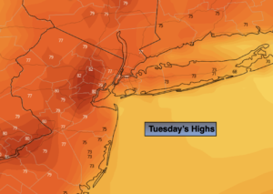
Tuesday:
Mostly sunny. Highs in the lower 80s.
Catch me on the Fox Weather Stream from 10am-1pm Friday. Find us on Tubi, Roku TV and YouTube TV and as always the Fox Weather App. It’s Free!