Synopsis:
Early morning showers are possible East as a weak front moves offshore. The sun should return during the afternoon with temperatures several degrees above the average high of 78º.
Another unsettled period is likely tonight into Thursday morning as low pressure moves swiftly through the region from the Southwest. Periods of rain and thunderstorms are likely. Some of the rainfall could be heavy. The sun will return during the afternoon.
Friday will feature high pressure building into the region. Plenty of sunshine and warm readings are anticipated.
Saturday looks to be wet at this time as low pressure moves up the Appalachians.
Sunday will be the better half of the weekend. Sun and clouds are expected with seasonable readings.
Stay tuned.
Keep it here for a no hype, no nonsense forecast.
Wednesday:
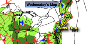
Early morning scattered showers East, otherwise skies will become partly sunny. Warm. Highs in the lower to mid 80s. West to Southwest winds at 5-10mph.
Tonight:
Areas of rain developing. Chance of a thunderstorm. Some of the rain could be heavy late. Lows 60º-65º. South winds at 8-12mph.
Thursday:
A chance of rain and thunderstorms during the morning. Some afternoon sun. Highs in the upper 70s.
Friday:
Mostly sunny. Highs around 80º.
Saturday:
Mostly cloudy with showers likely. Cooler. Highs in the lower 70s.
Sunday:
Partly sunny. Seasonable. Highs in the upper 70s.
Catch me on the Fox Weather Stream from 10am-1pm Wednesday. Find us on Tubi, Roku TV and YouTube TV and as always the Fox Weather App. It’s Free!