Synopsis:
Today will feature clouds in the morning with increasing sunshine in the afternoon as low pressure moves off the Southeast coast. It will be more comfortable with readings near the seasonal averages of the lower 80s.
It’ll be a June gem this weekend. A northwest flow will keep the temperatures and humidity at check. Saturday will be breezy with sunshine and seasonal readings. Sunday will be a carbon copy of Saturday, minus the breeze.
The next chance of showers and storms will come Monday with low pressure moving into the Northeast. We desperately need the rain as the drought in the area continues to worsen.
The sun will return on Tuesday along with typical temperatures for this time of the year.
Stay tuned.
Keep it here for a no nonsense, no hype forecast…
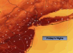
Friday:
Partly sunny. Highs in the lower 80s. West to Northwest winds at 10-20mph.
Tonight:
Mostly clear. Lows in the mid 60s in the City, the 50s inland. West to Northwest winds at 10-15mph.
Saturday:
Mostly sunny. Breezy. Highs around 80º.
Sunday:
Mostly sunny. Highs in the lower to mid 80s.
Monday:
Mostly cloudy. Showers and storms likely. Highs in the upper 70s.
Tuesday:
Partly sunny. Highs in the lower 80s.