Synopsis:
Today will feature a warm push of air and higher humidity. Isolated late day storms are possible with an approaching cool front. Most areas should remain storm-free.
Friday and the weekend will be bright with near seasonal temperatures as a Northwest wind takes hold.
The next chance of showers and storms will come Monday with low pressure moving into the Northeast. We desperately need the rain as the drought in the area continues to worsen.
Stay tuned.
Keep it here for a no nonsense, no hype forecast…
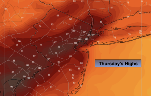
Thursday:
Partly sunny, warmer and more humid. Chance of late day storms. Breezy. Highs in the upper 80s. West to Southwest winds at 15-25mph with gusts to 35mph.
Tonight:
Partly cloudy. Lows in the mid 60s in the City, the 50s inland. West winds at 10-20mph.
Friday:
Partly sunny. Highs in the lower 80s.
Saturday:
Mostly sunny. Breezy. Highs around 80º.
Sunday:
Mostly sunny. Highs in the lower to mid 80s.
Monday:
Mostly cloudy. Showers and storms likely. Highs in the upper 70s.