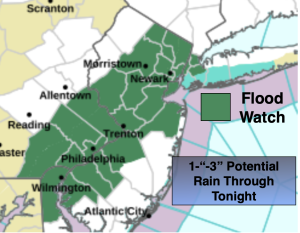
Synopsis:
Low pressure and a warm front will move toward the region today. It will become more humid under mainly cloudy skies. Showers and storms will be scattered through early afternoon. Much of the time will be dry. The best chance of showers and storms looks to be between 4pm and midnight. Some of the storms maybe isolated severe over parts of NJ. Local downpours are likely. Flooding is a concern for parts of NJ and NYC. The potential is there for one to three inches of rain. We desperately need the rainfall, but it maybe too much of a good thing in a short period of time. Remember, if you encounter a flooded roadway, turn around, don’t drown.
The action should wind down overnight.
A cool front will be along the coast on Tuesday. Another round of showers and storms are possible in the morning through early afternoon. Late day sun is possible.
Wednesday and Thursday will be gems with weak high pressure in the vicinity. Abundant sunshine and warm temperatures are expected.
A few storms are possible Friday under a mix of clouds and sun.
Stay tuned.
Keep it here for a no nonsense, no hype forecast…
Monday:
Cloudy. Becoming more humid. Scattered showers and storms. Local downpours. Highs in the upper 70s. Southeast winds at 8-12mph.
Tonight:
Scattered showers and storms early. Local downpours. Remaining mostly cloudy. Lows in the mid 60s in the City, the lower 60s inland. Southeast to Southwest winds at 5mph.
Tuesday:
Scattered showers and storms through early afternoon. Highs around 80º.
Wednesday:
Sunny. Warm. Highs in the mid 80s.
Thursday:
Partly sunny. Warm. Highs in the mid 80s.
Friday:
Partly sunny. Warm. Chance of a thunderstorm. Highs in the mid 80s.