Synopsis:
Canadian high pressure will dominate our weather through today. We’ll continue with the cold shoulder of Spring with readings almost ten degrees below average. The average high is in the lower 50s. Skies will be sun-filled despite the chill.
A storm over the Southeast will be accompanied by a coastal front on Saturday. This coastal front will be the focus for heavy rain for our region. The computer models continue with a heavy band of precipitation over much of the area. 1″-3″+ of rain is possible. The heaviest rain looks to be along the I-95 corridor. A Flood Watch has been posted for Saturday. Never drive through flooded roadways. You can’t judge how deep the water is- TURN AROUND, DON’T DROWN.
On Sunday we’ll dry out with readings near seasonable readings. The wind will be busy.
It’ll be a fine start to the workweek with strong high pressure funneling in from Eastern Canada. The sun will dominate.
Stay tuned.
Keep it here for a no nonsense, no hype forecast.
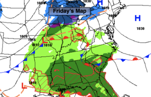
Friday:
Mostly sunny. Highs in the lower to mid 40s. Northwest to South winds at 5-10mph with gusts to 20mph later in the day.
Tonight:
Thickening clouds. Rain developing after midnight. Lows in the lower 40s in the City, the 30s inland. Southeast winds at 5-10mph.
Saturday:
Rain, heavy at times. Highs in the lower 50s.
Sunday:
Sunny. Breezy. Highs in the upper 40s.
Monday:
Sunny. Seasonable. Highs in the lower 50s.
Tuesday:
Mostly sunny. Highs in the lower 50s.