Synopsis:
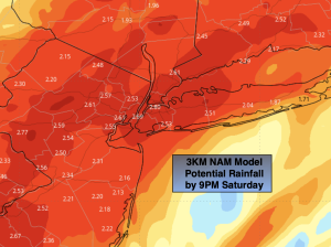
A storm over the Southeast will be accompanied by a coastal front today. This coastal front will be the focus for heavy rain for our region as the low moves up the coast. The computer models continue with a heavy band of precipitation over much of the area. 1″-3″+ of rain is likely. The heaviest rain looks to be along the I-95 corridor. A Flood Watch continues. Never drive through flooded roadways. You can’t judge how deep the water is- TURN AROUND, DON’T DROWN. Winds will increase along the immediate coast today and for all areas after the front passes later this afternoon and early evening. Gusts between 40-50mph are possible. Because the ground is so saturated weak rooted trees may topple. A nasty Saturday for sure.
The rain will end from West to East this evening and skies will clear. Winds will still be gusty but not as strong as the early part of the night.
On Sunday we’ll dry out. There will be a chill and the wind will add a bite. Skies will at least be sunny.
It’ll be a fine start to the workweek with strong high pressure funneling in from Eastern Canada. The sun will dominate.
The next chance of shower will come on Wednesday as a weakening front approaches.
Stay tuned.
Keep it here for a no nonsense, no hype forecast.
Saturday:
Rain, heavy at times. Becoming windy at the coast. Highs in the lower 50s. East to Southeast winds at 10-20mph with increasing gusts to 40mph.
Tonight:
Rain ends this evening. Windy. Lows in the lower to mid 30s in the City, the 20s inland. North to Northwest winds at 15-30mph with gusts to 40-50mph early.
Sunday:
Sunny. Breezy. Highs in the mid to upper 40s.
Monday:
Sunny. Seasonable. Highs in the lower 50s.
Tuesday:
Mostly sunny. Highs in the lower 50s.
Wednesday:
Mostly cloudy. Chance of showers. Highs in the lower 50s.