Synopsis:
Canadian high pressure will dominate our weather through Friday. We’ll experience the cold shoulder of Spring with readings almost ten degrees below average. The average high is in the lower 50s. Overnight lows in all areas will be below freezing. Skies will be sun-filled despite the chill.
Saturday will feature a storm on the map to our South . The computer models continue with a heavy band of precipitation over much of the area. The heaviest rain looks to be along the coast. 1″-2″+ of rain is possible.
On Sunday we’ll dry out with readings near seasonable readings. The wind will be busy.
It’ll be a fine start to the workweek with strong high pressure funneling in from Eastern Canada.
Stay tuned.
Keep it here for a no nonsense, no hype forecast..
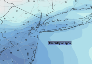
Thursday:
Mostly sunny, breezy and chilly. Highs in the lower 40s. West to Northwest winds at 10-20mph with gusts to 30mph.
Tonight:
Clear and cold. Lows in the upper 20s in the City, the upper teens and 20s inland. Northwest winds diminishing to 5-10mph.
Friday:
Partly sunny. Highs in the mid 40s.
Saturday:
Rain, heavy at times. Highs in the lower 50s.
Sunday:
Sunny. Breezy. Highs in the upper 40s.
Monday:
Sunny. Seasonable. Highs in the lower 50s.