Synopsis:
A weak cool front will push into the area today accompanied by clouds and just the threat of an isolated shower. It will still be mild.
Our string of above average temperatures will continue for the last weekend of Winter. Saturday will be mostly sunny. St. Patrick’s Day will feature more clouds than sun with a chance of an isolated shower as a front moves in.
Seasonable readings are expected for Monday (near 50º).
Spring arrives on Tuesday. It’ll be a chilly greeting as cold air from Canada moves into the region.
Stay tuned.
Keep it here for a no nonsense, no hype forecast..
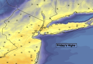
Friday:
Mostly cloudy. An isolated shower possible. Mild. Highs in the mid to upper 60s. Southwest to Northwest winds at 8-15mph.
Tonight:
Becoming mostly clear. Lows in the lower to mid 40s along the urban corridor the 30s to around 40º inland. Northwest winds at 5mph.
Saturday:
Mostly sunny. Highs in the mid to upper 50s.
St. Patrick’s Day:
More clouds than sun. An isolated shower. Highs in the upper 50s.
Monday:
Partly sunny. Cooler. Highs around 50º.
Tuesday:
Partly sunny. Cooler. Highs in the mid 40s.