Synopsis:
Today through Friday feature a Spring feel as high pressure over the Southeast brings up a mild flow.
A weak front will push into the area on Friday with more clouds and possibly a few light showers.
The above average temperature stretch will continue into the weekend. Saturday will be mostly sunny. St. Patrick’s Day will feature more clouds than sun with a chance of a few showers as a front moves in.
Seasonable readings are expected for Monday, the last day of Winter.
Stay tuned.
Keep it here for a no nonsense, no hype forecast..
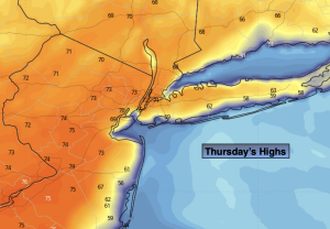
Thursday:
Partly sunny. Warm. Highs in the lower 70s. The 60s along coast. Light South winds.
Tonight:
Mostly cloudy. A few spotty showers possible. Mild. Lows in the lower to mid 50s along the urban corridor the 40s inland. Light South to Southeast winds.
Friday:
Mostly cloudy. Scattered showers possible. Mild. Highs in the mid to upper 60s.
Saturday:
Partly sunny. Highs in the mid 50s.
St. Patrick’s Day:
More clouds than sun. Chance of afternoon showers. Highs in the mid to upper 50s.
Monday:
Partly sunny. Cooler. Highs around 50º.