Synopsis:
Today through Friday feature a Spring feel as high pressure over the Southeast brings up a mild flow.
A weak front will push into the area on Friday with more clouds and possibly a few light showers, but it will still be mild!
The above average temperature stretch will continue into the weekend. Saturday will be mostly sunny. St. Patrick’s Day will feature more clouds than sun with a chance of a few showers as a front moves in.
Stay tuned.
Keep it here for a no nonsense, no hype forecast..
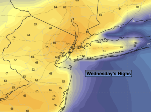
Wednesday:
Sunny. Mild. Highs in the mid to upper 60s. Much cooler at the coast. West to Southwest winds at 5-10mph. Winds will be off the water at the coast.
Tonight:
Mostly clear. Mild. Lows in the lower to mid along the urban corridor the 40s inland. Light Winds.
Thursday:
Partly sunny. Warm. Highs near 70º.
Friday:
Mostly cloudy. Scattered showers possible. Mild. Highs in the mid to upper 60s.
Saturday:
Partly sunny. Highs in the mid 50s.
St. Patrick’s Day:
More clouds than sun. Chance of afternoon showers. Highs in the mid 50s.