Synopsis:
Any showers early tonight will end. Skies will become partly cloudy late as low pressure moves into Southeastern Canada.
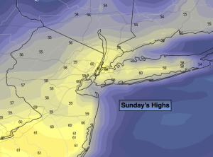
Sunday will be the brighter and milder half of the weekend as high pressure dries the Northeast out. Readings will be almost ten degrees above the average high of the lower 50s.
Monday will start off with sun, but clouds will increase rapidly during the day with showers likely by mid to late afternoon as weak low pressure slides to our South. Rain is likely Monday night.
Bright, seasonable conditions are expected Tuesday through Thursday. The latest guidance has diminished any development of low pressure along or off the coast.
Stay tuned.
Keep it here for a no nonsense, no hype forecast.
Tonight:
Evening scattered showers and an isolated thunderstorm, otherwise becoming partly cloudy. Lows in the upper 30s to lower 40s. Northeast to West winds at 10-20mph with higher gusts early, diminishing to 8-12mph.
Sunday:
Sunny. Mild. Highs in the lows 60s.
Monday:
Sun early, otherwise thickening clouds with showers likely by mid to late afternoon. Highs in the mid 50s.
Tuesday:
Partly sunny. Highs in the lower 50s.
Wednesday:
Sunny. Highs in the lower 50s.
Thursday:
Sunny. Highs in the lower 50s.