Synopsis:
The sun will dominate the second half of the weekend as high pressure dries the Northeast out. Readings will be almost ten degrees above the average high of the lower 50s.
Moonlit skies are in the forecast tonight with most readings remaining above freezing.
Monday will start off with sun, but clouds will increase rapidly during the day with showers likely by early to mid afternoon as weak low pressure slides to our South. A few hours of steady rain is expected for the evening commute.
Bright, seasonable conditions are expected Tuesday through Thursday as high pressure gains dominance over the Eastern Seaboard.
Stay tuned.
Keep it here for a no nonsense, no hype forecast.
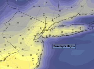
Sunday:
Sunny. Mild. Highs in the lows 60s. West winds at 10-20mph.
Tonight:
Clear. Highs in the lower to mid 40s along the urban corridor, the upper 20s and 30s inland. West to Northeast winds less than 5mph.
Monday:
Sun early, otherwise thickening clouds with showers likely by mid afternoon from West to East. A few hours of steady rain by the evening commute. Highs in the lower to mid 50s.
Tuesday:
Partly sunny. Highs in the lower 50s.
Wednesday:
Sunny. Highs in the lower 50s.
Thursday:
Sunny. Highs in the lower 50s.