Synopsis:
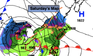
Low pressure will move into the Eastern Great Lakes today. A moist flow off the ocean ahead of a warm front will increasing our shower chances by midday (the majority of the morning will be dry). On and off showers with areas of drizzle are likely into this evening with readings just below the average high of the lower 50s.
Any showers early tonight will end. Skies will become partly cloudy late.
Sunday will be the brighter and milder half of the weekend as high pressure dries the Northeast out.
Monday will start off with sun, but clouds will increase rapidly during the day with showers likely by mid to late afternoon as weak low pressure slides to our South.
At this time JMW is keeping Tuesday and Wednesday dry. The computer models were all over the place with the placement of a storm. The latest guidance has diminished any development considerably. A mix of sun and clouds is expected with near seasonable readings.
Stay tuned.
Keep it here for a no nonsense, no hype forecast.
Saturday:
Mainly dry much of the morning. Scattered showers and areas of drizzle developing toward midday. Cooler. Highs in the upper 40s. Becoming breezy. Highs in the 4os to around 50º. East winds increasing to 10-20mph with gusts to 35mph during the afternoon at the coast.
Tonight:
Evening scattered showers and an isolated thunderstorm, otherwise becoming partly cloudy. Lows in the upper 30s to lower 40s. Northeast to West winds at 10-20mph with higher gusts early, diminishing to 8-12mph.
Sunday:
Sunny. Mild. Highs in the lows 60s.
Monday:
Sun early, otherwise thickening clouds with showers likely by mid to late afternoon. Highs in the mid 50s.
Tuesday:
Partly sunny. Highs in the lower 50s.
Wednesday:
Partly sunny. Highs in the lower 50s.