Synopsis:
Thickening clouds will be the forerunner of the developing low pressure that will throw late day rain our way during this afternoon. Wet snow will fall North and West. The starting time looks to be any time after Noon West to East.
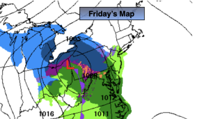
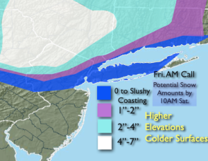
Upper level energy will be diving out of the Great Lakes and spawning a coastal low. The low will track to the South of the region and give the area a round of precipitation this afternoon and ending during the late morning hours on Saturday. The potential is for rain or a mix for coastal areas, possibly ending as some snow. Farther inland a mix or snow is likely with a likely accumulation. Above is the Friday AM Call potential amounts by late Saturday morning. This will be an elevation accumulation. If you reside in a county that has varying elevations, that may mean the difference of several inches of snow within a few miles. Take these amounts as a generalization. Also, the colder surfaces will have the final totals. Pavement and concrete will have a much lower slushier amount. These snow bands will most likely change as new computer guidance comes in.
Sunday definitely will be the better half of the weekend with brighter skies and seasonable readings as high pressure influences the region. It will be a brief break, unfortunately.
The next potential storm is on the map for Monday as low pressure develops along or off the coast. The track and all the typical questions still need to be answered. This system will be a stronger low that will affect the region Friday Night and Saturday. Rain will develop for most areas during the morning. The rain could possibly change to snow Monday night as the storm bombs out off the coast. Again, this is a potential. Much can change in the next few days. I just want you to be aware of the possible scenario. If the storm is too far off the coast lighter precipitation will fall.
Tuesday will feature the departing storm with some morning precipitation giving way to late day sun.
March is roaring now.
Stay tuned. Keep it here for a no nonsense, no hype forecast.
Friday:
Thickening clouds. Rain developing during the afternoon. Snow likely North and West. Highs in the mid 40s then falling late day. Northeast to Southeast winds at 5mph.
Tonight:
Rain, mix or snow depending on location. Lows around in the lower to mid 30s along the urban corridor, the upper 20s inland. East to North/Northeast winds at 5-15mph.
Saturday:
AM Snow. A mix likely going over to snow before ending at the coast. Highs in the upper 30s and lower 40s.
Sunday:
Mostly sunny and breezy. Highs in the mid 40s.
Monday:
Potential for rain, a mix well inland. Highs in the mid 40s.
Tuesday :
Potential morning mix or snow. Some PM sun. Highs around 40º.