

Synopsis:
Mainly sunny skies are expected today with winds abating as high pressure settles over the East coast. Highs will be near average which is the mid to upper 40s.
On Friday any sun will give way to clouds. Developing low pressure will throw late day rain our way. Wet snow will fall North and West.
JMW continues to gain confidence in the evolution of the next storm for Friday evening into Saturday. Upper level energy will be diving out of the Great Lakes and spawning a coastal low. The models are coming into better agreement. The low will track to the South of the region and give the area a round of precipitation starting Friday evening and ending during the late morning hours on Saturday. The potential is for rain or a mix for coastal areas, possibly ending as some snow. Farther inland a mix or snow is likely with a likely accumulation. Above are the first guess maps that I used from the National Weather Service. I mostly agree with this at this time. I will update this later today with my own graphic. The precipitation will end Saturday and skies may break for some sun later in the day.
Sunday definitely will be the better half of the weekend with brighter skies and seasonable readings as high pressure influences the region. It will be a brief break, unfortunately.
The next potential storm is on the map for Monday as low pressure develops along or off the coast. The track and all the typical questions still need to be answered. This system will be a stronger low that will affect the region Friday Night and Saturday. March is roaring now.
Stay tuned. Keep it here for a no nonsense, no hype forecast.
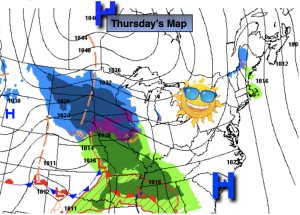
Thursday:
Mostly sunny. Highs in the mid to upper 40s. Northwest winds diminishing to 5-10mph by afternoon.
Tonight:
Partly cloudy. Lows around in the lower to mid 30s along the urban corridor, the upper 20s inland. North winds at 5-15mph.
Friday:
Sun to late clouds. Chance of rain by late day. Snow likely North and West. Highs in the mid 40s then falling late day.
Saturday:
AM Snow. A mix likely going over to snow before ending at the coast. Highs in the upper 30s and lower 40s.
Sunday:
Mostly sunny and breezy. Highs in the mid 40s.
Monday:
Potential for rain or snow. Highs around 40º.