Synopsis:
The wind will stay busy through today due to the difference in strong weather systems. Intense low pressure be draped over the North Atlantic with strong high pressure centered over central Canada. Mainly sunny skies are expected today and Thursday with winds abating by later Thursday. Highs will range near average-the mid 40s.
On Friday winds will relax high pressure noses down from Canada. Any sun will give way to clouds.
JMW is gaining more confidence in the evolution of the next storm for Friday evening into Saturday. Upper level energy will be diving out of the Great Lakes and spawning a coastal low. The models are starting to come into agreement. The low will track to the South of the region and give the area a round of precipitation starting Friday evening and ending during the morning on Saturday. The potential is for rain or a mix for coastal areas, possibly ending as some snow. Farther inland a mix or snow is likely with a likely accumulation. A few inches North and West is the first guess at this time. The precipitation will end Saturday and skies may break for some sun later in the day.
Sunday definitely will be the better half of the weekend with brighter skies and seasonable readings as high pressure influences the region.
Stay tuned. Keep it here for a no nonsense, no hype forecast.
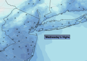
Wednesday:
Mostly sunny. Windy and seasonable. Highs in the mid 40s. Northwest winds qt 15-25mph with gusts to 30mph.
Tonight:
Partly cloudy, breezy and cold. Lows around freezing along the urban corridor, the upper 20s inland. Northwest winds at 10-20mph.
Thursday:
Mostly sunny. Highs in the mid to upper 40s.
Friday:
Sun to late clouds. Chance of rain or a mix by evening. Highs in the mid 40s.
Saturday:
Potential for some snow. A mix likely going over to snow before ending at the coast. Highs in the upper 30s and lower 40s.
Sunday:
Mostly sunny and breezy. Highs in the mid 40s.