Synopsis:
The sun will return today with readings around seasonable levels of the mid 40s. Winds will increase and become quite gusty. The wind will actually be brisk from the North due to the difference in strong weather systems. Intense low pressure be draped over the North Atlantic with strong high pressure centered over central Canada. A mix of sun and clouds is expected with highs around seasonable levels.
On Friday winds will relax high pressure noses down from Canada. It’ll be a fine clouds to the workweek.
Looking ahead, there is a potential system to watch as upper level energy will be diving out of the Great Lakes and most likely spawning a coastal low. Where this low forms, how strong it is and how rapidly it moves are questions that won’t be answered for a few days. The outcome of this scenario will determine our forecast for Saturday. As of this writing there is a possibility of rain or snow.
Stay tuned. Keep it here for a no nonsense, no hype forecast.
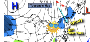
Tuesday:
Becoming partly sunny and windy. Highs in the lower to mid 40s. Northwest winds increasing to 15-25mph with gusts to 35mph.
Tonight:
Partly cloudy, windy and cold. Lows in the upper 20s to around 30º along the urban corridor, the 20s inland. Northwest winds at 15-25 with gusts to 35mp. .
Wednesday:
Mostly sunny. Breezy and seasonable. Highs in the mid 40s.
Thursday:
Mostly sunny. Breezy. Highs in the mid to upper 40s.
Friday:
Mostly sunny. Highs in the mid to upper 40s.
Saturday:
Potential for some rain or snow. Highs in the upper 30s and lower 40s.