Synopsis:
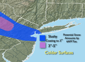
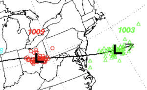
March has quickly developed a weather event up his or her sleeve. Low pressure pressure will move rapidly from Ohio to off the Delaware coast tonight. The small system now looks to carry a bit of a bunch as it strengthens (2nd map above) as it moves just South of the area. There will be a narrow band of snow or mixed precipitation from the Poconos to the Central NJ coast. The timing is toward midnight to before sunrise-a quick hitter. In areas where the snow is the steadiest and temperatures are around or below freezing, a coating to three inches on colder surfaces is possible by sunrise. The streets, pavement and sidewalks will have retained the heating of the day and will have a lower accumulation. Where this narrow band sets up, how heavy the precipitation, how quickly it moves through and how cold your area is will make all the difference in amounts received. These bands are not etched in stone. If you live within 10 miles of a band your amounts could go either way. Don’t concentrate on your exact location, but the general vicinity.
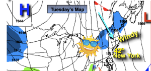
The sun will return Tuesday later in the morning with readings around seasonable levels of the mid 40s.
Wednesday and Thursday will feature a brisk North wind created by the difference in strong weather systems. Intense low pressure be draped over the North Atlantic with strong high pressure centered over central Canada. A mix of sun and clouds is expected with highs around seasonable levels.
On Friday winds will relax high pressure noses down from Canada. It’ll be a fine clouds to the workweek.
Looking ahead, there is a potential system to watch as upper level energy will be diving out of the Great Lakes and most likely spawning a coastal low. Where this low forms, how strong it is and how rapidly it moves are questions that won’t be answered for a few days. The outcome of this scenario will determine our forecast for Saturday. As of this writing there is a possibility of rain or snow. There is a lot of chatter from non meteorologists putting false information in the publics ear. You know where to turn, to find a no hype, no nonsense forecast.
Stay tuned.
Tonight:
Thickening clouds. An area of snow or mixed rain and snow over parts of the region. Lows in the mid 30s along the urban corridor, the upper 20s to around freezing inland. Northwest winds at 5-10mph.
Tuesday:
Becoming partly sunny and breezy. Highs in the lower to mid 40s. Northwest winds increasing to 15-25mph with gusts to 30mph.
Wednesday:
Mostly sunny. Breezy and seasonable. Highs in the mid 40s.
Thursday:
Mostly sunny. Breezy. Highs in the mid to upper 40s.
Friday:
Mostly sunny. Highs in the mid to upper 40s.
Saturday:
Potential for some rain or snow. Highs in the upper 30s and lower 40s.