Synopsis:
A colder airmass will work in for the last day of January and into February’s debut on Wednesday. Today may feature a brief rain of snow shower in the morning, otherwise more clouds than sun is expected. On Wednesday, a disturbance on the front may bring an area of snow showers into the region in the morning. The best chance of this happening is over Southern areas, otherwise a mix of clouds and sun is expected. Highs will be at or just below the average of the upper 30s for both days.
A tranquil Thursday is in the forecast as weather systems will be weak over the Northeast. Readings will moderate some.
An arctic front will push through Friday morning. Remember back to Christmas Weekend? This will be a similar blast with high temps starting off in the 30s during the morning and free falling into the teens by late day. Wind chills by the evening will be near zero. A slap in the face heading out doors for sure.
Frigid sunshine will greet us for the first Saturday of February. A strong Arctic high will settle over the region. Temperatures will remain at least ten to fifteen degrees below freezing for afternoon highs.
Stay tuned.
Keep it here for a no hype, no nonsense forecast.
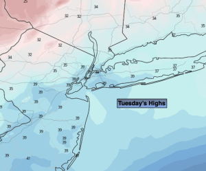
Tuesday:
Scattered morning rain or snow shower, otherwise a mix of clouds and sun. More seasonable. Highs in the upper 30s. Northwest winds at 10-15mph.
Tonight:
Mostly cloudy. Spotty snow showers possible. Lows in the upper 20s along the urban corridor, the teens and lower 20s inland. North winds 5mph.
Wednesday:
Potential of snow showers, mainly South in the morning. Clouds and sun. Colder. Highs in the lower to mid 30s.
Thursday:
Sun and clouds. Highs around 40º.
Friday:
Mostly sunny, windy and turning sharply colder . Tumbling temperatures during the day! Morning highs in the lower to mid 30s with readings falling into the teens by evening.
Saturday:
Frigid sunshine. Highs in the teens to around 20º.