Synopsis:
January 2023 has come to a close and is the warmest January on record for Central Park. This is a 154 year old record. Record keeping began in 1869. Simply amazing. The old record was January 1932, the mean temperature for the month was 43.2º. This January the mean temperatures was a sultry 43.5º.
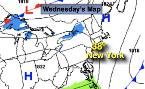
Scattered snow showers are possible with the most concentrated area along the coast and to the South and East through mid morning. A dusting to coating of snow is possible mainly near the coast and parts of Long Island. A disturbance on a front to the South riding along an old frontal boundary will be responsible for the flakes. The sun will return for all areas during the day on Wednesday. Highs will seasonable for February’s debut.
A tranquil Thursday is in the forecast as weather systems will be weak over the Northeast. Readings will moderate some.
An arctic front will push through Friday morning. Remember back to Christmas Weekend? This will be a similar blast with high temps starting off around 30º during the morning and free falling into the teens by late day. Wind chills by the evening will be near zero. A slap in the face heading out doors for sure.
Frigid sunshine will greet us for the first Saturday of February. A strong Arctic high will settle over the region. Temperatures will remain at least ten to fifteen degrees below freezing for afternoon highs.
Readings will skyrocket on Sunday as the Arctic high rapidly moves offshore and a return Southwest flow develops. Readings will be at least twenty degrees higher than Saturday. The latter half of the weekend will definitely be the better half.
Stay tuned.
Keep it here for a no hype, no nonsense forecast.
Wednesday:
Scattered snow showers in many areas. Increasing sunshine. Highs in the mid to upper 30s. North to Northwest at 5-10mph.
Tonight:
Clear and cold. Lows in the mid to upper 20s along the urban corridor, the teens inland. North to West winds at 5mph.
Thursday:
Sun and clouds. Highs in the lower 40s.
Friday:
Mostly sunny, windy and turning sharply colder . Tumbling temperatures during the day. Early morning highs around 30º falling into the teens by evening.
Saturday:
Frigid sunshine. Highs around 20º.
Sunday:
Partly sunny. Much milder. Highs in the lower 40s.