Synopsis
No major changes are expected for today as a cold front approaches. It’ll still mild ahead of the front and the clouds will continue to dominate. A spot shower is possible tonight with the passage of the front.
A colder airmass will work in for the last day of January and into February’s debut on Wednesday. It’ll remain dry. Highs will be at or just below the average highs of the upper 30s.
A tranquil Thursday is in the forecast as weather systems will be weak over the Northeast. Readings will moderate some.
An arctic front will push through Friday morning. Remember back to Christmas Weekend? This will be a similar blast with high temps starting off in the 30s during the morning and free falling into the teens by late day. Wind chills by the evening will be near zero.
There is STILL no snow in the forecast.
Stay tuned.
Keep it here for a no hype, no nonsense forecast
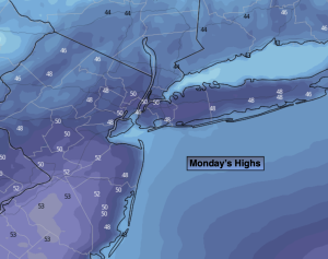
Monday:
Mostly cloudy. Mild. Highs in the upper 40s to lower 50s. West to Southwest winds at 5mph.
Tonight:
Mostly cloudy. Spotty showers possible. Lows in the mid 30s along the urban corridor, around 30º inland. Southwest to North winds 5-10mph.
Tuesday:
Partly sunny. More seasonable. Highs in the upper 30s.
Wednesday:
Mostly sunny. Colder. Highs in the lower to mid 30s.
Thursday:
Sun and clouds. Highs around 40º.
Friday:
Mostly sunny, windy and turning sharply colder . Tumbling temperatures during the day! Morning highs in the lower to mid 30s with readings falling into the teens by evening.