Synopsis
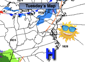
A mix of sun and clouds is expected today with tolerable temperatures as high pressure moves to the Southeast coast.
Skies will be mainly clear tonight.
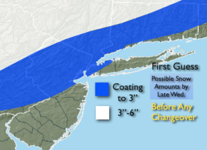
Low pressure will develop over the Southern states on Wednesday and move Northeast. Precipitation will move in during the mid to late morning. It looks cold enough for most areas to get a hit of wet snow at the onset (the exception being Southern areas). The potential is there for an accumulation before the changeover to rain later in the day. First guess map is above. A period of heavy rain is likely Wednesday evening. Well North a heavy mix is possible, hence the higher snow amounts.
Skies will brighten on Thursday as the storm departs out to sea. Readings will be several degrees above the average high of the upper 30s.
By Friday, readings will cool down to near average temperatures as a Canadian airmass works in under mostly sunny skies.
The beginning of the weekend looks decent for late January as conditions will remain tranquil along the East coast.
Stay tuned.
Keep it here for a no hype, no nonsense forecast
Tuesday:
Partly sunny. Highs in the mid 40s. West winds 10-20mph.
Tonight:
Mostly clear. Lows around freezing along the urban corridor, the the upper teens and 20s inland. Light West winds becoming North.
Wednesday:
Wet snow developing by mid to late morning, rain over Southern sections. Snow eventually mixing with rain and changing to rain from South to North by late day. Highs rising from the 30s into the 40s during the evening.
Thursday:
Partly sunny. Highs in the mid 40s.
Friday:
Mostly sunny. More seasoanble. Highs in the upper 30s.
Saturday:
Partly sunny. Highs in the mid 40s.