Synopsis:
Any early sun will give way to mostly cloudy skies today as upper level energy works in behind the departing surface low. An isolated shower is possible. Readings will be about ten degrees above the average high.
High pressure will move in Saturday with any clouds giving way to sunny skies.
Any sunshine Sunday morning will give way to increase clouds. Rain is likely during the afternoon as another low moves up from the South and West. A mix of rain and snow is possible North & West.
Any leftover clouds and early morning rain or snow showers on Monday should give way to a brighter afternoon sky.
Tuesday will be the best day of the next five with wall to wall sunshine and our continuation of above average readings.
Stay tuned.
Keep it here for a no hype, no nonsense forecast.
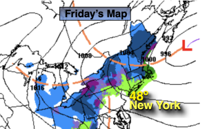
Friday:
Mostly cloudy. Isolated rain showers, wet snow showers North. Highs in the mid to upper 40s. West to Northwest winds at 10-20mph with gusts to 30mph.
Tonight:
Mostly cloudy. Lows in the mid 30s along the urban corridor, the upper 20s to around freezing inland. Northeast to West winds at 10-15mph.
Saturday:
Clouds to sun. Highs in the lower 40s.
Sunday:
Morning sun giving way to increasing clouds. Rain developing during the afternoon. Rain and snow possible inland. Highs in the mid 40s.
Monday:
Morning clouds to sun. Highs in the mid 40s.
Tuesday:
Sunny. Highs in the mid 40s.