
Synopsis:
The weekend will be decent and chilly with highs around seasonable levels- the upper 30s to around 40º. A large high will build from Eastern Canada South to the Gulf of Mexico. The difference in pressure from a developing offshore storm and the high will create gusty winds. The storm over the Western Atlantic will result in more clouds for today for coastal areas. Farther to the West the sun will dominate.
MLK Day will feature sunshine and tolerable readings as the high moves overhead.
Clouds will rule on Tuesday as a low weakens as it heads from the Great Lakes into Ontario. An isolated shower is possible.
Well above average temperatures will greet us on Wednesday with abundant sunshine as high pressure dominates.
Thursday will feature low pressure moving out of the Ohio valley into the Northeast. Showers will develop during the day. A potential mix at the onset is in the forecast.
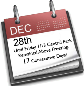
From December 28th through January 13th the temperature in Central Park remained about freezing. That’s a 17 day stretch! That has to be a record or close to one. The Southeast ridge dominated. Will that pattern break down?
Stay tuned.
Keep it here for a no hype, no nonsense forecast.\
Sunday:
Mostly sunny. More clouds East. Breezy. Highs in around 40º. North 15-25mph with higher gusts at the coast.
Tonight:
Clear to partly cloudy. Lows in the upper 20s along the urban corridor, the teens and lower 20s inland. North winds diminishing to 8-15mph.
Martin Luther King Jr. Day:
Mostly sunny. Highs in lower to mid 40s.
Tuesday:
Mostly cloudy. An isolated shower is possible. Highs mid to upper 40s.
Wednesday:
Mostly sunny. Mild. Highs in the lower 50s.
Thursday:
Mostly cloudy. Showers likely. A potential mix at the onset well North. Highs in the 40s.