Synopsis:
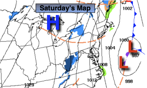
The weekend will be decent and chilly with highs finally around seasonable levels- the upper 30s to around 40º. A large high will build from Eastern Canada South to the Gulf of Mexico. The difference in pressure from a developing offshore storm and the high will create gusty winds. The storm over the Western Atlantic will result in more clouds for today. As the storm moves farther out to sea, the high will take over giving our region a mostly sunny Sunday.
MLK Day will feature sunshine and tolerable readings as the high moves overhead.
Clouds will rule on Tuesday as a low weakens as it heads from the Great Lakes into Western NY state. An isolated shower is possible.
Well above average temperatures will greet us on Wednesday with abundant sunshine as high pressure dominate.
Our snowless Winter continues and there is no major change in the extended computer models to think otherwise. Sorry snow lovers, the Pacific jet stream continues to scream.
Stay tuned.
Keep it here for a no hype, no nonsense forecast.
Saturday:
More clouds than sun. Breezy. More seasonable. Highs in the upper 30s. North winds at 15-25mph with higher gusts at the coast.
Tonight:
Mostly cloudy. Much colder than recent nights (wow, its January!) Lows around or just below freezing along the urban corridor, the 20s inland. North to Northwest winds at 15-25mph with higher gusts.
Sunday:
Mostly sunny. Highs in around 40º.
Martin Luther King Jr. Day:
Mostly sunny. Highs in lower to mid 40s.
Tuesday:
Mostly cloudy. An isolated shower is possible. Highs mid 40s.
Wednesday:
Mostly sunny. Mild. Highs in the lower 50s.