Synopsis:
On Tuesday and Wednesday high pressure will move through our region. A mix of sun and clouds is expected. Our above average readings will continue.
Thursday, as a maritime flow will develop ahead of a Northward moving warm front. Areas of drizzle or showers are in the forecast.
Rain is likely Thursday night and Friday as a low develops over the Ohio Valley and moves well to our West into Upstate New York. This, like all of the other storms is a warm track, hence the rain and not snow.
Some of the computer models develop a second storm off our coast on Saturday with a second piece of upper level energy. If this materializes, another round of some rain, possibly even mixed with snow is possible. At this time this is a low potential, in fact the latest computer guidance keeps most of the precipitation offshore.
Stay tuned.
Keep it here for a no hype, no nonsense forecast.
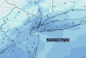
Tuesday:
Sun and clouds. Highs in the mid 40s. Northwest winds at 5-10mph.
Tonight:
Partly cloudy. Lows in the lower 30s in the City, the 20s inland. Northwest to Northeast winds at 5mph.
Wednesday:
Sun to clouds. Highs in the lower to mid 40s.
Thursday:
Cloudy. Areas of showers or drizzle likely. Highs in the mid to upper 40s.
Friday:
Rain likely, mainly in the morning. Mild. Highs in the mid 50s.
Saturday:
Mostly cloudy. Just a chance of rain for snow showers. Cooler. Highs in around 40º.