Synopsis:
Tonight will be clear with tolerable temperatures for January standards.
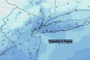
On Tuesday and Wednesday high pressure will move through our region. Abundant sunshine is expected Tuesday. Sun will give way to clouds on Wednesday as the system pushes offshore. Our above average readings will continue.
Thursday, as a maritime flow will develop ahead of a Northward moving warm front. Areas of drizzle or showers are in the forecast.
Rain is likely Thursday night and Friday as a low develops over the Ohio Valley and moves well to our West into Upstate New York. This, like all of the other storms is a warm track, hence the rain and not snow.
Some of the computer models develop a second storm off our coast on Saturday with a second piece of upper level energy. If this materializes, another round of some rain, possibly even mixed with snow is possible. At this time this is a low potential.
Stay tuned.
Keep it here for a no hype, no nonsense forecast.
Tonight:
Clear. Lows in the mid 30s in the City, the 20s inland. West Northwest winds at 8-12mph.
Tuesday:
Sunny. Highs in the mid 40s. Northwest winds at 5-10mph.
Wednesday:
Sun to clouds. Highs in the lower to mid 40s.
Thursday:
Cloudy. Areas of showers or drizzle likely. Highs in the mid to upper 40s.
Friday:
Rain likely, mainly in the morning. Mild. Highs in the mid 50s.
Saturday:
Potential for some rain and or wet snow. Cooler. Highs in around 40º.