Synopsis:
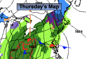
A warm front will approach on today with scattered showers this morning. Well North a bit of sleet or light wet snow may fall. There will be several hours of dry time later this morning through early afternoon. Steady rain will move in later in the day.
Rain is likely tonight as a low develops over the Ohio Valley and moves well to our West into Upstate New York. This, like all of the other storms is a warm track, hence the rain and not snow. Temperatures tonight will continue to rise into the 50s at the coast, the 40s inland once the warm front moves to our North. Winds will pick up as well.
Morning shower Friday will give way to some sun during the afternoon as the cool front sweeps offshore. It’ll be mild with readings in the lower to mid 50s during the morning. Temperatures will fall some during the afternoon.
The weekend looks bright and chilly with highs around seasonable levels- the upper 30s to around 40º. A large high will build from Eastern Canada South to the Gulf of Mexico.
MLK Day will feature sunshine and tolerable readings.
Stay tuned.
Keep it here for a no hype, no nonsense forecast.
Thursday:
Cloudy with areas of light rain and drizzle this morning. A bit of light wet snow or sleet well North for a time. There will be several hour of dry time before steadier rain moves in later in the day. Highs rising through the 30s and 40s. East to Southeast winds at 5-10mph.
Tonight:
Periods of rain. Rising temperatures through the 40s and 50s! Becoming windy, especially at the coast. Southeast to South winds increasing to 10-20mph with gusts over 30mph.
Friday:
Scattered morning showers, otherwise becoming partly sunny. Mild. Highs in the lower to mid 50s. Readings will fall into the 40s during the afternoon.
Saturday:
Mostly sunny. More seasonable. Highs around 40º.
Sunday:
Sunny. Highs in around 40º.
Martin Luther King Jr. Day:
Mostly sunny. Highs in lower to mid 40s.