Synopsis:
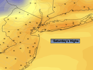
Any morning clouds will give way to mainly sunny skies today. It’ll feel more like Spring as the area awaits a cooler push of air. Highs will be about fifteen degrees above the average highs of the mid 50s.
A cold front will move through the region tonight as weak low pressure develops off the coast. This will result in showers overnight into Sunday morning. Colder air will work in for Sunday as the flow comes from Canada . Monday will most likely be the chilliest day of the season so far. The chill will continue on Tuesday despite abundant sunshine as cold high pressure dominates.
Another low will develop and move up the coast Wednesday. Showers are in the forecast.
Stay tuned.
Keep it here for a no hype, no nonsense forecast.
Saturday:
Early morning clouds, otherwise becoming partly sunny. Warm. Highs in the 60s to around 70º along the urban corridor. West to Northwest winds at 10-20mph and diminishing.
Tonight:
Scattered showers. Lows in the 40s throughout. Northwest winds at 5mph.
Sunday:
Morning showers, otherwise becoming partly sunny. Much cooler. Highs in the lower 50s.
Monday:
Sunny. Chilly. Highs in the upper 40s.
Tuesday:
Sun to clouds. Highs in the upper 40s.
Wednesday:
Mostly cloudy. Showers likely. Highs in the lower 50s.