Synopsis:
It’s a reality check today as November returns and our Spring fling becomes a mere memory. A Canadian airmass will move in and bringing our temperatures more closer to average-the mid 50s. The sun will continue to dominate through midweek.
Thursday will feature above average temperatures as we get on the milder side of the high.
By Friday, a cool front will head our way. In addition to this feature, a tropical low (once Nicole) will be moving up the coast. Rain will likely develop Friday afternoon and possibly become heavy at times at night.
Early morning rain Saturday will give way to mainly sunny skies. Temperatures will be above average.
Stay tuned.
Keep it here for a no hype, no nonsense forecast.
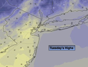
Tuesday:
Mostly sunny, breezy and cooler. Highs in the mid 50s. North winds at 10-20mph with gusts to 25mph.
Tonight:
Clear and cold. Lows in the upper 30s in the City, the 20s & 30s inland. Northeast winds diminishing to 5mph.
Wednesday:
Sunny. Cool. Highs in the mid 50s.
Thursday:
Sunny. Milder. Highs in the lower 60s.
Friday:
Thickening clouds. Rain likely by afternoon. Mild. Highs in the mid to upper 60s.
Saturday:
Early morning rain. Becoming sunny. Mild. Highs in the mid 60s.