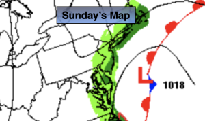
Synopsis:
Weak Atlantic low pressure will affect the region today with clouds and showers by afternoon, a far cry from Saturday’s gorgeous weather.
A period of rain is likely tonight as the low moves through the region.
Monday through Wednesday will be an unsettled period. The threat of scattered showers and areas of drizzle are in the forecast as the flow will be coming off the ocean and weak disturbances move in from time to time. It will not be a washout. Readings will be near average (the lower 60s), and then get above average by midweek.
We’ll finally get a break from the dismal weather by Thursday as high pressure moves in. Mostly sunny skies are expected with mild readings.
Stay tuned.
Keep it here for a no hype, no nonsense forecast.
Sunday:
Cloudy. Showers likely by afternoon. Highs in the lower 60s. Northeast 8-12mph.
Tonight:
On and off rain likely. Lows in the lower 50s in the City, the upper 40s North and West. Northeast winds 8-12mph.
Monday:
Spotty Drizzle. Highs in the lower 60s.
Tuesday:
Spotty Drizzle. Milder. Highs in the upper 60s.
Wednesday:
Clouds, some sun. Scattered showers possible. Highs in the upper 60s.
Thursday:
Partly sunny. Mild. .Highs in the upper 60s.