Synopsis:
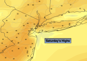
Strong high pressure will dominate the Northeast today. This will result in a spectacular Saturday with abundant sunshine and mild temperatures. Readings will be several degrees above the average high of 63º. Today will be the better half of the weekend.
On Sunday, weak Atlantic low pressure will affect the region with clouds and showers by afternoon.
The threat of scattered showers remains Monday morning as the low moves into New England and dissipates. It doesn’t look to be too wet of a day with the sun most likely making an appearance during the afternoon.
Tuesday should be dry and mild as we get a break from the incoming disturbances.
Another impulse will work in off the ocean on Wednesday. More clouds are expected with the possibility of showers.
Stay tuned.
Keep it here for a no hype, no nonsense forecast.
Saturday:
Sunny. Mild. Highs in the mid to upper 60s. South to Southeast winds at 5mph.
Tonight:
Clear early, increasing clouds late. Lows in the lower 50s in the City, 30s & 40s elsewhere. Southeast to Northeast winds less than 5mph.
Sunday:
Cloudy. Showers likely by afternoon. Highs in the lower 60s.
Monday:
Morning scattered showers possible, otherwise becoming partly sunny during the afternoon. Highs in the lower 60s.
Tuesday:
Partly sunny. Milder. Highs in the upper 60s.
Wednesday:
More clouds. Scattered showers possible. Mild. Highs in the upper 60s.