Synopsis:
A spotty early morning shower is possible otherwise skies will become mainly sunny skies and it will much warmer. You’ll notice a decrease in the humidity. Weak high pressure will move over the region.
High pressure will build along the Northeast coast through Thursday. The bright, warm conditions will continue. Readings will be several degrees above the average high of 79º.
By Friday the winds will turn to the West ahead of a cool front. This will result in a spike in temperatures. Scattered late storms are possible with the approaching system.
Stay tuned.
Keep it here for a no hype, no nonsense forecast.
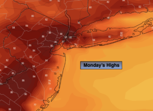
Monday:
A spot early morning shower otherwise mostly sunny and much warmer. Highs in the mid to upper 80s. Northwest to West winds at 5-10mph.
Tonight:
Partly cloudy. Lows in the mid 60s in the City, the 50s inland. Northwest to North at 5mph.
Tuesday:
Mostly sunny. Highs in the lower to mid 80s.
Wednesday:
Sunny. Highs in the lower 80s.
Thursday:
Mostly sunny. Highs around 80º.
Friday:
Partly sunny. Very warm. Scattered late day storms possible. Highs in the upper 80s to around 90º.
Catch me on the Fox Business Network from 6am-9am and the Fox Weather Stream until Noon this weekend. Find us on Tubi, Roku TV and YouTube TV and as always the Fox Weather App. It’s Free!