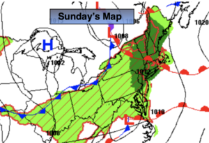
Synopsis:
Clouds will dominate Sunday as moisture from the South and a disturbance from the West combine resulting scattered showers just about anytime. An isolated thunderstorm is possible. Some of the rain will locally heavy. It will not be a washout. There will be a noticeable increase in humidity. Readings will be several degrees below the average high of 78º.
Early morning showers are possible Monday, otherwise skies will become sunny and it will become much warmer. The bright, warm conditions will continue through Thursday as high pressure moves in from the West.
Stay tuned.
Keep it here for a no hype, no nonsense forecast.
Sunday:
Mostly cloudy with scattered showers and possible isolated storms. Highs in the lower to mid 70s. Southeast winds at 5-10ph.
Tonight:
Mostly cloudy. Scattered showers possible. Lows in the mid 60s in the City, the 50s inland. Winds South to West at 5mph.
Monday:
Partly sunny. Warm. Highs in the mid 80s.
Tuesday:
Mostly sunny. Highs in the lower to mid 80s.
Wednesday:
Sunny. Highs around 80º.
Thursday:
Mostly sunny. Highs in the lower 80s.
Catch me on the Fox Business Network from 6am-9am and the Fox Weather Stream until Noon this weekend. Find us on Tubi, Roku TV and YouTube TV and as always the Fox Weather App. It’s Free!