Synopsis:
Today and Wednesday will be comfortable with a refreshing air mass over the region as high pressure over New England supplies a cool flow off the chilly ocean. More clouds than sun is expected as moisture gets trapped at the lower levels of the atmosphere with the wind off the water.
Thursday will be dominated by clouds as moisture builds from the South. Scattered showers are possible.
A cool front will approach Friday with a better chance of showers.
The beginning of the Memorial Day weekend may start off with a few showers but the front should clear the coast and allow for some afternoon sun.
At this time the Sunday and Memorial Day should be dry and bright with moderating temperatures. Keep your fingers crossed. It usually is a difficult task to get all 3 days as winners.
Stay tuned.
Keep it here for a no hype, no nonsense forecast.
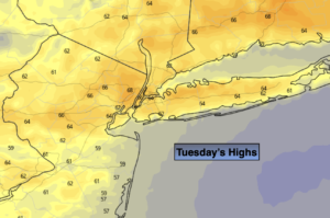
Tuesday:
Clouds, some sun. Cooler. Highs in the upper 60s. East to Southeast winds at 8-12mph.
Tonight:
Partly cloudy. Lows in the mid in urban areas, the upper 40s inland. East winds at 5mph.
Wednesday:
Clouds, some sun. Highs around 70º.
Thursday:
Mostly cloudy with scattered showers possible. Highs around 70º.
Friday:
Mostly cloudy with showers likely. Highs in the mid 70s.
Saturday:
Chance of early showers, otherwise becoming partly sunny. Highs in the mid 70s.
Catch me on the Fox Business Network from 6am-9am this weekend and on the Fox Weather Stream until Noon. Find us on Tubi, Roku TV and YouTube TV and as always the Fox Weather App. It’s Free!