Synopsis:
The hot spell is over. Relief has arrived behind a cool front. Readings will be near the average high of 73º under mainly sunny skies.
Tuesday and Wednesday will be comfortable with a refreshing air mass over the region as high pressure moves overhead. More clouds than sun is expected.
Thursday will be dominated by clouds as moisture builds from the South. Showers are possible but it shouldn’t be a washout.
A cool front will approach Friday with a better chance of showers.
Stay tuned.
Keep it here for a no hype, no nonsense forecast.
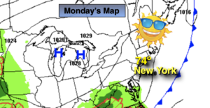
Monday:
Mostly sunny. Much more comfortable. Highs in the mid 70s. North winds at 8-12mph.
Tonight:
Mostly cloudy. Lows in the upper 50s in urban areas, the lower 50s inland. Northeast winds at 5mph.
Tuesday:
Clouds and sun. Cooler. Highs around 70º.
Wednesday:
Clouds and sun. Highs in the upper 60s.
Thursday:
Mostly cloudy with scattered showers possible. Highs in the lows 70s.
Friday:
Mostly cloudy with shower likely. Highs in the mid 70s.
Catch me on the Fox Business Network from 6am-9am this weekend and on the Fox Weather Stream until Noon. Find us on Tubi, Roku TV and YouTube TV and as always the Fox Weather App. It’s Free!