Synopsis:
Today will feature another cold blast with readings below freezing. At least the sun will be shining as Arctic high pressure dominates. Winds will be busy making feel even colder.
Tonight will be frigid. Lows will be in the teens and single digits inland.
On Sunday, readings in urban areas may crack freezing. It’ll be mainly sunny as high pressure begins to move off the coast.
Monday will be quite pleasant for early February with readings near 40º under a mix of sun and clouds.
A storm will be to off our coast on Tuesday, more clouds than sun is expected. If the system comes close enough a bit of rain or wet snow may fall. This shouldn’t be a big deal.
Bright and tranquil conditions are expected for midweek as weak high pressure dominates.
Stay tuned.
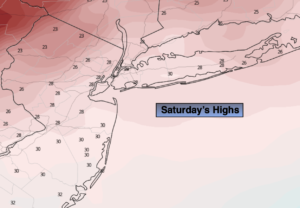
Saturday:
Mostly sunny, breezy and much colder. Highs in the upper 20s. Northwest winds at 15-25mph.
Tonight:
Clear and very cold with diminishing winds. Lows in the teens in urban areas, the single digits Northwest. Northwest to North winds at 5-10mph.
Sunday:
Partly sunny. Highs in the lower 30s.
Monday:
Partly sunny. Highs in the lower 40s.
Tuesday:
Clouds and sun. A bit of rain or wet snow possible. Highs in the lower 40s.
Wednesday:
Mostly sunny. Highs in the lower to mid 40s.