Synopsis:
Readings today in urban areas will flirt freezing. It’ll be mainly sunny as high pressure begins to move off the coast.
Tonight will start off mainly clear. Clouds will roll in late. It won’t be as cold as recent nights.
Monday will feature a trough of low pressure extending into our area from a developing offshore storm. The forecast now includes the chance of light rain and or light wet snow. It shouldn’t amount to much as this will be a quick hitting event with temperatures a few degrees above freezing.
The storm will move well off our coast on Tuesday, any clouds will give way to some sun.
Bright and tranquil conditions are expected for midweek as weak high pressure dominates. Temperatures will be above the average high of 40º. In fact, by Thursday it will be quite mild.
Stay tuned.
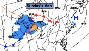
Sunday:
Mostly sunny. Highs in the lower 30s. Northeast to Southeast winds at 5mph.
Tonight:
Clear early, becoming mostly cloudy late. Lows in the upper 20s in urban areas, the teens and 20s North and West. Southeast to Northeast winds less than 5mph.
Monday:
Cloudy with a bit of light rain and or light wet snow. Highs in the upper 30s.
Tuesday:
Clouds and sun. Highs in the lower 40s.
Wednesday:
Mostly sunny. Highs in the lower 40s.
Thursday:
Partly sunny. Milder. Highs in the mid 40s.